|
Digital
History>eXplorations>The
World Before 1492
Exploration
3: Timbuktu
Salt
comes from the north, gold from the south, and silver from
the country of the white men, but the word of God and the
treasures of wisdom are only to be found in Timbuktu.
An old West African proverb
Essential
Questions
-
What caused the decline of Timbuktu?
- When
was Timbuktu discovered by Europeans?
-
How did Islam shape the development of Mali and of Timbuktu?
|
In
the popular imagination, Timbuktu is the most remote
and isolated part of the world. But 500 years ago, Timbuktu
was the legendary city of gold. It was a transit point
and a financial and trading center for trade across
the Sahara. It dominated the gold trade. It was a place
of mystery and faraway riches.
Timbuktu
was founded in 1080 and within 300 years had become
one of the era's most important trading points. Timbuktu
was an influential Islamic intellectual centre, a
cosmopolitan
multicultural city of commerce and learning and the
second-largest imperial court in the world.
When
much of Europe was struggling out of the Dark Ages, the
emperor of Timbuktu was having stunning mosques built,
and
thousands
of scholars from as far as Islamic India and Moorish Spain
were studying in the city. |
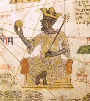
Detail
from a 14th century Catalan map showing Mansa Musa,
king of Timbuktu,
holding a gold nugget which he is offering
to a Muslim merchant who is approaching on camel.
Catalan Atlas, Bibliotheque Nationale, Paris |
|
Then
it was a city of 100,000 and so rich that even the slaves
were decorated with gold. In 1324, a king of Mali, Mansa Musa,
traveled with a caravan of a hundred camels bearing 300 pounds
of gold each (equal to perhaps $135 million today).
The
legend of his wealth was recorded in maps, particularly the
Catalan Atlas of 1375, which showed an African ruler enthroned
like a European monarch with a crown on his head and an orb
and scepter in his hand.
Read
an account of Mansa Musa's
visit to Cairo in 1324 written
by Al-Umari, an Arab historian.
As
recently as 1963, a famous British historian Hugh Trevor-Roper
said: "Perhaps in the future, there will be some African
history to teach. But at present there is none. There is only
the history of Europeans in Africa. The rest is darkness."
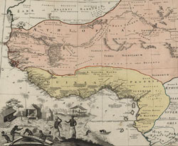
Detail from a map, Guinea
Proper, Not Including the Whole of Africa, but Only
that Part Known to the Geographers as Lower Ethiopia).
Nuremberg: Homannianorum Heredum, 1743.
Credit: Geography and Map Division, Library of Congress |
Trever-Roper
was wrong. Timbuktu was once a center of religion, culture,
and learning, as well as a commercial crossroads on the trans-Saharan
caravan route. Situated at the strategic point where the Sahara
touches on the River Niger, it was the gateway for African
goods bound for the merchants of the Mediterranean, the courts
of Europe and the larger Islamic world. It was involved in
a thriving commerce in gold, salt, and slaves. When the Renaissance
was barely stirring in Europe, wandering scholars were drawn
to Timbuktu's manuscripts all the way from North Africa, Arabia
and even Persia.
In
1591, Moroccan soldiers invaded and looted Timbuktu, ending
the city’s grandeur and taking thousands of inhabitants
as slaves. By the time Timbuktu was discovered by Europeans,
the palaces of its kings and other fine buildings had crumbled
to dust.
Resources
(Links will open in a new window; close that window
to return to this page)
The
following links are organized thematically.
The
History
Mansa
Musa, the Malian King
Maps
Guinea
Proper, Not Including the Whole of Africa, but Only
that Part Known to the Geographers as Lower Ethiopia).
Nuremberg: Homannianorum Heredum, 1743.
Credit: Geography and Map Division, Library of Congress |
This
map from the eighteenth century shows clearly the change
in trade and travel that had occurred by 1743.
Rather
than being viewed as part of the larger continent, West
Africa is presented with a focus on the sea routes that
had replaced the land caravan routes to the area.
Click
map to enlarge. |
Images
|